 I now practice 1-2 times per week before a race. I take a map
with me on my long runs. I will stop and try to figure out where
I am at on the map. I try to stop by a draw or ridge, so I can
learn to see what the different features look like to scale. This
is great Adventure Racing Navigation practice for me.
I now practice 1-2 times per week before a race. I take a map
with me on my long runs. I will stop and try to figure out where
I am at on the map. I try to stop by a draw or ridge, so I can
learn to see what the different features look like to scale. This
is great Adventure Racing Navigation practice for me.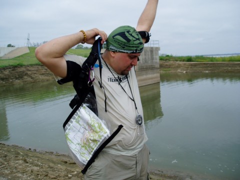
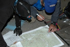 When plotting
points for a race you are often rushed. Though you may
feel rushed always recheck the points. This can cost you
time later if you mis-plot. It is tough to see teams take off
when you are re-checking points, but we've lost hours in a
race by not re-checking.
When plotting
points for a race you are often rushed. Though you may
feel rushed always recheck the points. This can cost you
time later if you mis-plot. It is tough to see teams take off
when you are re-checking points, but we've lost hours in a
race by not re-checking.
Home | About Me | Contact
Disclaimer | Build
Your Own Website | What's
New | Site Map
|
Home:Adventure
Racing: Adventure Racing Navigation
ADVENTURE RACING NAVIGATIONAdventure Racing Navigation or orienteering is great fun once you get the hang of it. I had a little trouble at first taking the topo map and visualizing it as actual land marks. Once you get over that hurdle however, navigating can be simple.There are lots of great navigation books and sites. I am going to give you some nav tips and some great resources. The below link is a great resource for learning land navigation. It is free and quite comprehensive. He is a little brash, but the information is great. Land Navigation Free Course I first took a Adventure Racing Navigation course from a former marine. I learned a lot and felt like I knew how to navigate, until I did a race. Boy was I wrong. We looked and looked...turned around...shot a back azimuth...turned circles. The trail was no where to be found. We ended up lost. We were a little afraid, thinking we'd be lost in the Ozarks. We had no back up system in case of emergency, no phone, gps, nothing. We finally figured out to shoot an azimuth toward a road. We just started bushwhacking on the bearing. When we finally found the road we were ecstatic. We jumped up and down and hugged. It was like Christmas!
After I thought I knew a lot about navigation my father-in-law bought me a book. This book is great for going beyond basic Adventure Racing Navigation. I studied this book nightly and really felt it took me to another level. He will teach you how to measure the percentage of grade, how to make the best route choice, triangulation and declination. Even if you already navigate as I did, I found a lot of useful information. The Essential Wilderness Navigator: How to Find Your Way in the Great Outdoors, Second Edition
ADVENTURE RACING NAVIGATION SUPPLIES
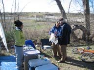
First of all you must protect your map. You'll need a water proof navigation bag.If you are just practicing navigation and not out for days, you can also use zip-lock bags. Just be careful as they can easily leak if submerged. The second thing is a good compass. The compass I like is the Brunton Adventure Racing Compass, as it has the UTM scale on it as well. Though I do not use this for plotting it is handy to re-plot in the field and for measuring distance. For plotting points you will need a UTM Plotter, sharpie, different color highlighters, and a pencil. You should mark your points in pencil the first time. When a teammate checks the point he/she can circle the point with a sharpie. You'll want the highlighters to mark your course for land navigation. We use different colors, such as blue for the water course. Remember to carry a pen or pencil and a highlighter in your map case. You may need to mark something in the field. For the paddling section of navigation a deck compass is great to have. It straps to your kayak shell and you can have a hands free compass, while you paddle. When you are in the mountains an altimeter is very handy, telling you the elevation. It is not 100% accurate and needs to be re-calibrated. The Suunto Vector is the altimeter I use. PLOTTING POINTS
Our team has a pair of people working together. One person calls out the points and the other plots. When they are finished the other pair does the same and checks the point. The second pair will mark the points with a sharpie, the first with a pencil. Practice calling out the numbers together before the race. Certain people have ways they like to call the numbers out for plotting. We have found it fastest to get the quadrant first, then plot the points. To help you remember which number goes first, I use this quote. Walk in the door and up the stairs. That simply means go to the right first (in the door) and up second (up the stairs). Below shows you my picks for some great books on Navigation.
|
Sign up for our Extreme Adventure FREE Sports-ZineExtreme Adventure Sports Zine
|
|
|
Subscribe To This Site


The link to your selling page can go here
Powered by Site
Build It! |
Copyright©2008 www.extreme-adventure-sports.com